Corryong, Mt Elliot
Victoria 3707, Australia
Sign In to get the latest weather!
It's free to join spedmo and start collaborating
Current Conditions
No Alerts.
Remember before every flight, check your equipment, reassess the conditions and ask yourself if 'I'm safe'?


Aaron Hughes posted a video
Paragliding Students at Corryong's Mt Elliot Launch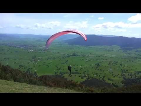
Pete's new students from Australian Paragliding Centre flying off Mt Elliot in Corryong. I've never seen it so lush and green.
9 km
6 km
Required Launch Wind Direction
Paragliding Students at Corryong's Mt Elliot Launch
Pete's new students from Australian Paragliding Centre flying off Mt Elliot in Corryong. I've never seen it so lush and green.
Aaron Hughes added this
Pete's new students from Australian Paragliding Centre flying off Mt Elliot in Corryong. I've never seen it so lush and green.
Aaron Hughes added this


Take Off
-36.1858, 147.976 : 932.0 m
Sunrise
6:34 AM
Sunset
7:18 PM
Time Zone
Australian Eastern Standard Time (+1100)
Near Corryong, 320km NE of Melbourne. Takeoff is visible from the town. Take the road out to Kancoban and drive to the far side of the mountain. Enter the gate at Fishers Track and follow it up to the tower. Vicroads Map 37 H4.
Westerly launch is a prepared earth ramp suitable for 1 PG/HG at a time. Below west launch, watch out for powerlines on the hill and in the valley. na. na. na.